


d'écho

bernir
User
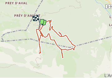

Length
10 km

Max alt
2027 m

Uphill gradient
399 m
Km-Effort
15.4 km

Min alt
1715 m

Downhill gradient
408 m
Boucle
Yes
Creation date :
2023-08-16 08:02:15.199
Updated on :
2023-08-17 22:50:39.611
5h25
Difficulty : Difficult

FREE GPS app for hiking
 SityTrail
IGN / Geographical institutes
SityTrail Plus
The world is yours!
About
Trail Walking of 10 km to be discovered at Provence-Alpes-Côte d'Azur, Hautes-Alpes, Les Vigneaux. This trail is proposed by bernir.
Positioning
Country:
France
Region :
Provence-Alpes-Côte d'Azur
Department/Province :
Hautes-Alpes
Municipality :
Les Vigneaux
Location:
Unknown
Start:(Dec)
Start:(UTM)
303512 ; 4964714 (32T) N.
Comments